 |
| by Water Encyclopedia |
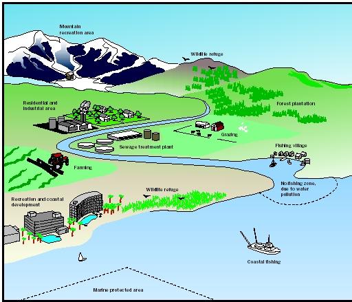
Protection, production, settlements, and infrastructure are the core development policies in terms of Land use. It's interesting to see the focus of development in the capital town of Ifugao. The core land use policy areas of the National Land Use Committee have been followed bringing better coordination between the local and national governments.
Lagawe holds public consultation on comprehensive land use planby Dan B. Codamon/ Philippine Information Agency/ October 28, 2011
LAGAWE, Ifugao, October 28 (PIA) -- To realize the long-term vision of this municipality as the soft broom and coffee manufacturing center in the province and as the service center of Northwestern Cordillera, the municipal government conducted a public consultation of its proposed Comprehensive Land Use Plan (CLUP).
The consultation aims to gather more inputs from the people before finalizing the plan to serve as the organizing concept for the identification, allocation, and proper location of various land-using activities of the CLUP.
The speakers presented and explained to the participants the end-state scenario as the basis of the drafting of the zoning ordinance which is an integral part of the land use plan.
The organization shall follow the four land use policy areas of the National Land Use Committee which are protection, production, settlements, and infrastructure.
The phases are designated as the Period of Developing the Urban Service Center from 2011-2020, the Period of Developing the Ecological-Culture Zone from 2021-2030, and the Period of Developing the Upland and Lowland Agricultural Zones from 2031-2040.
During the first phase, development investments shall be concentrated in the Poblacion urban growth center to enable Lagawe to position itself as the service center of the Northwestern Cordillera as well as provide safe, hazard-free alternative settlements for the residents of nearby barangays.
Under the second phase, five barangays are proposed to be the Ecological Cultural Zone that has the biggest source of water to be considered as watershed area.
To protect the area from further encroachment, the Sangguniang Bayan shall come up with an ordinance delineating and protecting the place as watershed area.
The area will be designed as a show case of sustainable upland settlement focused on agro-forestry and other models of sloping land agriculture and in the site master plan. Human footprint shall be minimized and the population density strictly controlled to maintain utmost sensitivity to the carrying capacity of fragile ecosystems.
Finally, during the period of Developing the Upland and Lowland Agricultural Production the site will be located at the least steep portion of the eastern portion of the town.
The idea is to develop this loop of agriculture producing barangays to produce upland or lowland crops not only to sustain the agricultural need of the whole populace of Lagawe but to be able to contribute to the economic activity in the trade and industry of the whole Northwestern Cordillera.*(JDP/DBC-PIA CAR,Ifugao)
No comments:
Post a Comment